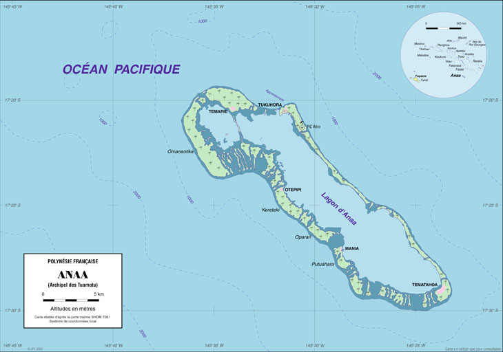
Anaa, Nganaa-nui (or Ara-ura)[2] is an atoll in the Tuamotuarchipelago, in French Polynesia. It is located in the north-west of the archipelago, 350km to the east of Tahiti. It is oval in shape, 29.5km in length and 6.5km wide, with a total land area of 38km2 and a population of 504. The atoll is made up by eleven small barren islands with deeper and more fertile soil than other atolls in the Tuamotus. The lagoon is shallow, without entrance, and formed by three main basins. Although it does not have any navigable access, the water of the lagoon renews by several small channels that can be crossed walking.
History
Landscape
The atoll of Anaa was known by the legendary cruelty of its soldiers who in the seventeenth century, dominated the north-west of the Tuamotus.
The Spanish expedition of Pedro Fernández de Quirós landed on Conversión de San Pablo on 10 February 1606, since identified as either Anaa or Hao.[3] The sighting of Anaa was recorded by French explorer Louis Antoine de Bougainville in 1768.[4]James Cook sighted it in 1769. Because of its shape, he called it Chain Island. Later, Anaa was visited by Spanish explorer Domingo de Bonechea,[5] on November 1 of 1772, who called it Isla de Todos los Santos (All Saints Island) because they arrived on All Saints' Day.
At the beginning of the nineteenth century, control of the atoll went to the Pomaré of Tahiti. Around 1850 Anaa was an active center of the nacre commerce and copra, with a maximum population of 2,000. The missionary competition between Mormons of North America and French Catholics led to a revolt in 1852, and an intervention by French colonial troops.
In 1878 and 1906 Anaa suffered severe hurricane damages and was completely flooded. After the hurricane of 1983, the only village was moved and reconstructed, incorporating a refuge shelter with capacity for all its population.
Anaa is located 66km south of Faaite Atoll, 78km from Tahanea Atoll and 377km east of Tahiti; and is an oval atoll 29.5km long and 6.5km wide, with a total area of 38km2. The coral reef is made up of eleven islets with deeper and more fertile soil than the other atolls of the Tuamotu, of which nine are named:
Kereteki, Mania, Omanaotika, Oparari, Otepipi, Putuahara, Teharie, Tematahoa and Tukuhora.[6]
The lagoon is shallow, with no navigable passages to the ocean, and consists of 3 main basins. Although it has no navigable passages, the lagoon water is renewed by several shallow channels that can be crossed on foot.
Geology
Geologically, the atoll is the coral outgrowth (105 meters) of the top of a large volcanic seamount of the same name (the "Anaa Ridge", 11,438 m3), measuring 3,415 meters from the seafloor, formed some 52.5-59.6 million years ago.[7]
Fauna and flora
The atoll is home to an endemic population of long-billed warblers and its lagoon has colonies of Cardium fragum.[8]
Tuuhora
The main village is Tuuhora, also called Tukuhora or Anaa, with a population of about 350. The other small villages like Temarie, Otepipi, Mania and Tematahoa have small seasonal population. The population subsists mainly on fishing, the cultivation of nacre and the production of copra.
Demography
The population was 530 in 2022,[1] and lives mainly from fishing, mother-of-pearl farming and copra production.
Pier at the Atoll
In 2017, the total population of Anaa was 494 people[9] and its evolution is as follows:
1983
1988
1996
2002
2007
2012
2017
2022
400
426
411
435
463
496
494
530
Sources: ISPF and Government of French Polynesia.
Religion
In 1850, Anaa was an active mother-of-pearl and copra trading centre, with a maximum population of 2000 people. In 1852, French colonial troops intervened, following an uprising resulting from competition between North American Mormons and French Catholics. Today, most of the population is affiliated with Christianity. The Catholic Church owns a religious building on the atoll (on Tukuhora) called St. Joseph's Church (Église de Saint-Joseph)[10] which is under the Metropolitan Archdiocese of Papeete based in Tahiti.
Economy
Most of the atoll's economic activity is related to fishing and fish farming, as well as copra production, with coconut plantations cultivated on virtually every motus (islets).
Anaa has an airfield (IATA code: AAA) near the main town of Tukuhora with a runway 1,400 meters long. On average, it handles about 140 flights and 3,500 passengers per year.[11]
Faaite is an atoll located 60km to the north of Anaa. The total surface of the atoll is of 230km2. Its dry land area has a surface of 9km2. The inner lagoon has a navigable channel to the ocean. The main village is Hitianau, with a total population of 246. It was discovered by John Turnbull in 1802, the first retailer of the Pacific who used the route of Tahiti to Hawaii. Historically the atoll also has been known as Miloradovich.
Tahanea
Tahanea is an atoll of 63km2, with three passages towards the interior of the lagoon. It is uninhabited and is visited occasionally. It was discovered by Domingo Bonaechea in 1772, who called it San Julian. It has also been known as Tchitschagof.
Motutunga
Motutunga is an uninhabited atoll, with a passage to the interior of the nonnavigable lagoon. Domingo Bonaechea called it San Blas. It has also been known as Adventure Island.


