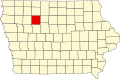
ENSIKLOPEDIA Cari Tekan Enter untuk memulai pencarian cepat. Kembali ke Ensiklopedia Arsip Wikipedia Indonesia Ware, Iowa Ware, Iowa Unincorporated community in Iowa, United StatesWare, IowaUnincorporated communityWare, IowaCoordinates: 42°47′25″N 94°45′33″W / 42.79028°N 94.75917°W / 42.79028; -94.75917CountryUnited StatesStateIowaCountyPocahontasElevation1,289 ft (393 m)Time zoneUTC-6 (Central (CST)) • Summer (DST)UTC-5 (CDT)Area code712GNIS feature ID462676[1] Ware is an unincorporated community in Sherman Township, Pocahontas County, Iowa, United States. Ware is 6 miles (9.7 km) northwest of Pocahontas. History Ware got its start following construction of the Chicago, Rock Island and Pacific Railroad through that territory. It was named for Francis L. Ware, who owned the town site.[2] The population was 75 in 1940.[3] References ↑ U.S. Geological Survey Geographic Names Information System: Ware, Iowa ↑ Flickinger, Robert Elliott (1904). The Pioneer History of Pocahontas County, Iowa. G. Sanborn. pp. 735. ↑ The Attorneys List. United States Fidelity and Guaranty Company, Attorney List Department. 1940. p. 314. vteMunicipalities and communities of Pocahontas County, Iowa, United StatesCounty seat: PocahontasCities Fonda Gilmore City‡ Havelock Laurens Palmer Plover Pocahontas Rolfe Varina Map of Iowa highlighting Pocahontas CountyTownships Bellville Cedar Center Colfax Cummins Des Moines Dover Garfield Grant Lake Lincoln Lizard Marshall Powhatan Roosevelt Sherman Swan Lake Unincorporatedcommunity Ware Ghost town Lizard Rubens Footnotes‡This populated place also has portions in an adjacent county or counties Iowa portal United States portal Authority control databases VIAF This article about the geography of Pocahontas County, Iowa is a stub. You can help Wikipedia by adding missing information.vte