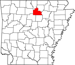
ENSIKLOPEDIA Cari Tekan Enter untuk memulai pencarian cepat. Kembali ke Ensiklopedia Arsip Wikipedia Indonesia Luber, Arkansas Luber, Arkansas Unincorporated community in Arkansas, United StatesLuber, ArkansasUnincorporated communityLuber, ArkansasShow map of ArkansasLuber, ArkansasShow map of the United StatesCoordinates: 35°45′56″N 92°05′02″W / 35.76556°N 92.08389°W / 35.76556; -92.08389CountryUnited StatesStateArkansasCountyStoneElevation1,207 ft (368 m)Time zoneUTC-6 (Central (CST)) • Summer (DST)UTC-5 (CDT)Area code870GNIS feature ID58097[1] Luber is an unincorporated community in Stone County, Arkansas, United States. Luber is located on unmarked gravel roads, 7.3 miles (11.7 km) south-southeast of Mountain View.[2] The Luber School, which is listed on the National Register of Historic Places, is located in Luber.[3] References ↑ "Luber". Geographic Names Information System. United States Geological Survey, United States Department of the Interior. ↑ Stone County, Arkansas General Highway Map (PDF) (Map). Arkansas State Highway and Transportation Department. 2001. Retrieved December 2, 2012. ↑ "National Register Information System". National Register of Historic Places. National Park Service. July 9, 2010. vteMunicipalities and communities of Stone County, Arkansas, United StatesCounty seat: Mountain ViewCities Fifty-Six Mountain View Map of Arkansas highlighting Stone CountyCDPs Fox Pleasant Grove Other unincorporatedcommunities Alco Allison Bothersome East Richwoods Flag Luber Marcella Melrose Mozart Newnata Old Lexington Onia Optimus Pleasant Hill Rushing St. James Timbo Turkey Creek West Richwoods Ghost town Harness Arkansas portal United States portal This article about a location in Stone County, Arkansas is a stub. You can help Wikipedia by adding missing information.vte