ENSIKLOPEDIA Cari Tekan Enter untuk memulai pencarian cepat. Kembali ke Ensiklopedia Arsip Wikipedia Indonesia Conaway, Virginia Conaway, VirginiaUnincorporated community in Virginia, United States Unincorporated community in Virginia, United StatesConaway, VirginiaUnincorporated communityConaway, VirginiaShow map of VirginiaConaway, VirginiaShow map of the United StatesCoordinates: 37°21′08″N 82°12′42″W / 37.35222°N 82.21167°W / 37.35222; -82.21167CountryUnited StatesStateVirginiaCountyBuchananElevation860 ft (260 m)Time zoneUTC-5 (Eastern (EST)) • Summer (DST)UTC-4 (EDT)Area code276GNIS feature ID1495419[1] Conaway is an unincorporated community in Buchanan County, Virginia, United States. Conaway is located along the Levisa Fork and U.S. Route 460, 8 miles (13 km) northwest of Grundy. Conaway had a post office until July 9, 1988.[2] References ↑ "Conaway". Geographic Names Information System. United States Geological Survey, United States Department of the Interior. ↑ "Postmaster Finder - Post Offices by ZIP Code". United States Postal Service. Archived from the original on April 28, 2019. Retrieved December 22, 2012. vteMunicipalities and communities of Buchanan County, Virginia, United StatesCounty seat: GrundyTown Grundy Map of Virginia highlighting Buchanan CountyCDPs Big Rock Breaks‡ Vansant Othercommunities Artia Bearwallow Conaway Council Davenport Deel Drill‡ Grimsleyville Harman Harman Junction Hurley Janey Jewell Valley Keen Mountain Leemaster Mavisdale Maxie Mount Heron Murphy Oakwood Page Patterson Paynesville Peapatch‡ Pearly Prater Pilgrims Knob Roseann Roth Rowe Shack Mills Shortt Gap Slate Stacy Thomas Tookland Vandyke Venia Vicey Weller Whitewood Wolford Footnotes‡This populated place also has portions in an adjacent county or counties Virginia portal United States portal This Buchanan County, Virginia state location article is a stub. You can help Wikipedia by adding missing information.vte
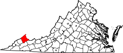 Map of Virginia highlighting Buchanan County

