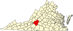
ENSIKLOPEDIA Cari Tekan Enter untuk memulai pencarian cepat. Kembali ke Ensiklopedia Arsip Wikipedia Indonesia Cifax, Virginia Cifax, VirginiaUnincorporated community in Virginia, United States Unincorporated community in Virginia, United StatesCifax, VirginiaUnincorporated communityBarn at The Cedars farmstead, a core part of the communityCifax, VirginiaShow map of VirginiaCifax, VirginiaShow map of the United StatesCoordinates: 37°24′40″N 79°24′27″W / 37.41111°N 79.40750°W / 37.41111; -79.40750CountryUnited StatesStateVirginiaCountyBedfordElevation938 ft (286 m)Time zoneUTC-5 (Eastern (EST)) • Summer (DST)UTC-4 (EDT)Area code540GNIS feature ID1499264[1] Cifax is an unincorporated community in Bedford County, Virginia, United States. Cifax is located at the junction of State Routes 643 and 644, 8.3 miles (13.4 km) northeast of Bedford. The Cifax Rural Historic District, which includes Cifax and the surrounding area, is listed on the National Register of Historic Places.[2] References ↑ "Cifax". Geographic Names Information System. United States Geological Survey, United States Department of the Interior. ↑ "National Register Information System". National Register of Historic Places. National Park Service. July 9, 2010. vteMunicipalities and communities of Bedford County, Virginia, United StatesCounty seat: BedfordTown Bedford Map of Virginia highlighting Bedford CountyCDPs Big Island Forest Moneta Montvale Stewartsville Unincorporatedcommunities Chamblissburg Cifax Coleman Falls Goode Goodview Hardy Huddleston Lowry Perrowville Thaxton Villamont Virginia portal United States portal Authority control databases InternationalVIAFNationalUnited StatesIsrael This Bedford County, Virginia state location article is a stub. You can help Wikipedia by adding missing information.vte